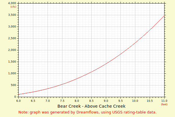
| Flow (in cfs) - last revised Mar 27, 2024 | ||||||||||
|---|---|---|---|---|---|---|---|---|---|---|
| Height (feet) | .0 | .1 | .2 | .3 | .4 | .5 | .6 | .7 | .8 | .9 |
| 3 | 0 | 0 | 0 | 1 | 1 | |||||
| 4 | 2 | 2 | 4 | 5 | 7 | 9 | 11 | 14 | 18 | 22 |
| 5 | 26 | 31 | 37 | 43 | 50 | 59 | 68 | 79 | 92 | 107 |
| 6 | 123 | 141 | 161 | 181 | 203 | 226 | 251 | 277 | 305 | 335 |
| 7 | 367 | 400 | 435 | 471 | 510 | 550 | 594 | 640 | 688 | 737 |
| 8 | 789 | 844 | 900 | 959 | 1020 | 1083 | 1148 | 1216 | 1287 | 1359 |
| 9 | 1435 | 1512 | 1592 | 1675 | 1760 | 1848 | 1939 | 2032 | 2128 | 2226 |
| 10 | 2328 | 2431 | 2538 | 2648 | 2760 | 2876 | 2994 | 3115 | 3239 | 3366 |
| 11 | 3496 | 3629 | 3765 | 3904 | 4046 | 4191 | 4339 | 4491 | 4646 | 4804 |
| 12 | 4965 | 5129 | 5297 | 5468 | 5642 | 5820 | 6000 | 6185 | 6373 | 6564 |
| 13 | 6758 | 6957 | 7158 | 7363 | 7572 | 7784 | 8000 | |||