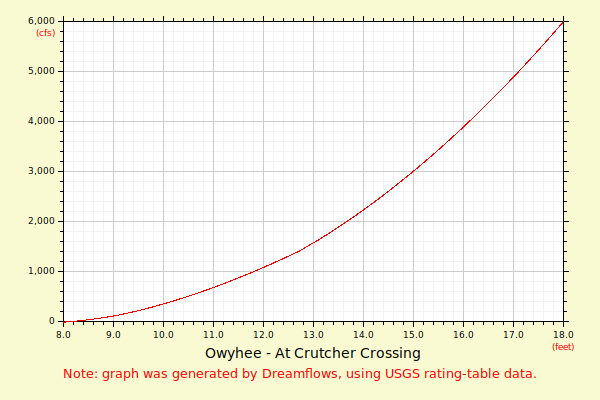
| Flow (in cfs) - last revised Apr 10, 2024 | ||||||||||
|---|---|---|---|---|---|---|---|---|---|---|
| Height (feet) | .0 | .1 | .2 | .3 | .4 | .5 | .6 | .7 | .8 | .9 |
| 8 | 8 | 15 | 24 | 33 | 44 | 56 | 69 | 83 | 98 | 114 |
| 9 | 130 | 149 | 170 | 192 | 215 | 239 | 264 | 290 | 316 | 344 |
| 10 | 372 | 401 | 431 | 462 | 494 | 526 | 560 | 594 | 628 | 664 |
| 11 | 700 | 737 | 775 | 813 | 852 | 892 | 932 | 973 | 1015 | 1057 |
| 12 | 1100 | 1144 | 1188 | 1233 | 1279 | 1325 | 1372 | 1419 | 1477 | 1535 |
| 13 | 1595 | 1656 | 1718 | 1782 | 1846 | 1912 | 1978 | 2046 | 2115 | 2185 |
| 14 | 2256 | 2328 | 2401 | 2476 | 2552 | 2628 | 2706 | 2785 | 2865 | 2946 |
| 15 | 3029 | 3112 | 3197 | 3282 | 3369 | 3457 | 3546 | 3636 | 3727 | 3820 |
| 16 | 3913 | 4008 | 4103 | 4200 | 4298 | 4397 | 4497 | 4599 | 4701 | 4804 |
| 17 | 4909 | 5015 | 5121 | 5229 | 5338 | 5448 | 5560 | 5672 | 5785 | 5900 |
| 18 | 6015 | 6132 | 6250 | 6369 | 6489 | 6610 | 6732 | 6856 | 6980 | 7106 |
| 19 | 7232 | 7360 | 7489 | 7619 | 7750 | 7882 | 8016 | 8150 | 8285 | 8422 |
| Height (feet) | .0 | .1 | .2 | .3 | .4 | .5 | .6 | .7 | .8 | .9 |
| 20 | 8560 | 8698 | 8838 | 8979 | 9121 | 9265 | 9409 | 9554 | 9701 | 9848 |
| 21 | 9997 | 10147 | 10297 | 10449 | 10602 | 10757 | ||||