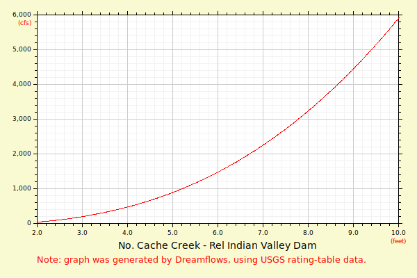
| Flow (in cfs) - last revised Jun 1, 2026 | ||||||||||
|---|---|---|---|---|---|---|---|---|---|---|
| Height (feet) | .0 | .1 | .2 | .3 | .4 | .5 | .6 | .7 | .8 | .9 |
| 2 | 0 | 1 | 2 | 3 | 4 | 6 | 9 | 13 | 18 | |
| 3 | 24 | 31 | 39 | 48 | 58 | 69 | 82 | 96 | 113 | 132 |
| 4 | 154 | 177 | 202 | 230 | 260 | 292 | 326 | 362 | 402 | 443 |
| 5 | 487 | 534 | 583 | 635 | 690 | 748 | 809 | 872 | 939 | 1008 |
| 6 | 1081 | 1157 | 1236 | 1318 | 1404 | 1493 | 1585 | 1681 | 1780 | 1883 |
| 7 | 1989 | 2099 | 2212 | 2330 | 2451 | 2576 | 2704 | 2837 | 2974 | 3114 |
| 8 | 3259 | 3370 | 3483 | 3598 | 3716 | 3836 | 3958 | 4083 | 4210 | 4339 |
| 9 | 4471 | 4606 | 4743 | 4882 | 5024 | 5168 | 5315 | 5465 | 5617 | 5771 |
| 10 | 5928 | 6088 | 6251 | 6416 | 6583 | 6754 | 6927 | 7103 | 7281 | 7463 |
| 11 | 7647 | 7833 | 8023 | 8215 | 8411 | 8609 | 8810 | 9013 | 9220 | 9430 |
| 12 | 9642 | 9858 | 10076 | 10297 | 10522 | 10749 | 10979 | 11212 | 11449 | 11688 |
| 13 | 11931 | 12176 | ||||||||