| Flow (in cfs) - last revised May 22, 2026 | ||||||||||
|---|---|---|---|---|---|---|---|---|---|---|
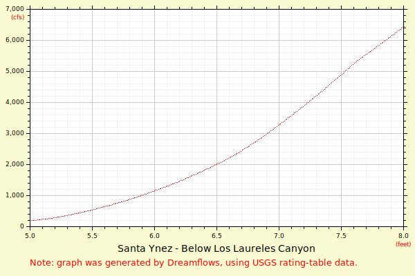
| Height (feet) | .0 | .1 | .2 | .3 | .4 | .5 | .6 | .7 | .8 | .9 |
| 3 | 0 | 1 | ||||||||
| 4 | 2 | 4 | 8 | 14 | 25 | 39 | 59 | 85 | 118 | 160 |
| 5 | 211 | 273 | 347 | 433 | 526 | 617 | 718 | 830 | 955 | 1091 |
| 6 | 1242 | 1403 | 1622 | 1849 | 2083 | 2326 | 2575 | 2831 | 3094 | 3362 |
| 7 | 3637 | 3918 | 4204 | 4495 | 4792 | 5094 | 5401 | 5712 | 6029 | 6350 |
| 8 | 6675 | 7005 | 7339 | 7677 | 8020 | 8366 | 8716 | 9071 | 9429 | 9791 |
| 9 | 10156 | 10525 | 10898 | 11274 | 11653 | 12036 | 12423 | 12812 | 13205 | 13602 |
| 10 | 14001 | 14403 | 14809 | 15217 | 15629 | 16043 | 16461 | 16881 | 17304 | 17730 |
| 11 | 18159 | 18591 | 19025 | 19463 | 19902 | 20345 | 20790 | 21238 | 21688 | 22141 |
| 12 | 22596 | 23054 | 23515 | 23977 | 24443 | 24911 | 25381 | 25853 | 26328 | 26805 |
| 13 | 27285 | 27767 | 28251 | 28737 | 29226 | 29717 | 30210 | 30706 | 31203 | 31703 |
| 14 | 32205 | 32709 | 33215 | 33723 | 34233 | 34746 | 35260 | 35777 | 36295 | 36816 |
| Height (feet) | .0 | .1 | .2 | .3 | .4 | .5 | .6 | .7 | .8 | .9 |
| 15 | 37338 | 37863 | 38390 | 38918 | 39449 | 39981 | 40516 | 41052 | 41590 | 42130 |
| 16 | 42672 | 43216 | 43762 | 44310 | 44859 | 45411 | 45964 | 46519 | 47076 | 47634 |
| 17 | 48195 | 48757 | 49321 | 49887 | ||||||