| Flow (in cfs) - last revised Feb 6, 2026 | ||||||||||
|---|---|---|---|---|---|---|---|---|---|---|
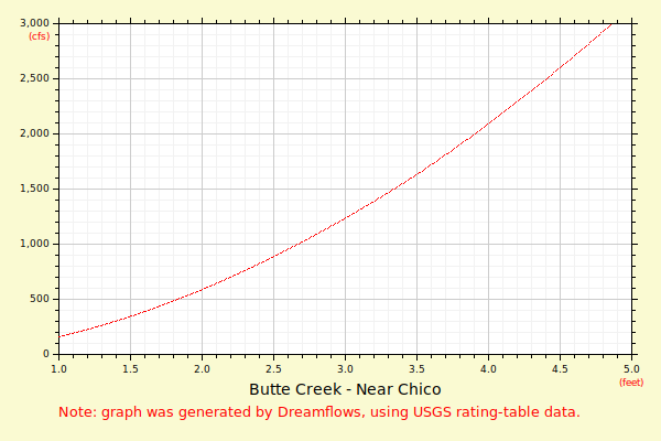
| Height (feet) | .0 | .1 | .2 | .3 | .4 | .5 | .6 | .7 | .8 | .9 |
| 0 | 62 | 85 | 111 | 139 | 170 | 204 | ||||
| 1 | 240 | 279 | 320 | 363 | 408 | 456 | 506 | 558 | 612 | 669 |
| 2 | 727 | 787 | 849 | 914 | 980 | 1048 | 1118 | 1190 | 1263 | 1339 |
| 3 | 1416 | 1495 | 1576 | 1659 | 1743 | 1830 | 1917 | 2007 | 2098 | 2191 |
| 4 | 2286 | 2382 | 2480 | 2581 | 2684 | 2789 | 2896 | 3004 | 3113 | 3225 |
| 5 | 3338 | 3452 | 3568 | 3686 | 3805 | 3926 | 4049 | 4173 | 4298 | 4425 |
| 6 | 4554 | 4684 | 4815 | 4948 | 5083 | 5219 | 5357 | 5496 | 5636 | 5778 |
| 7 | 5921 | 6066 | 6213 | 6360 | 6509 | 6660 | 6812 | 6966 | 7120 | 7277 |
| 8 | 7434 | 7593 | 7754 | 7915 | 8079 | 8243 | 8409 | 8576 | 8745 | 8915 |
| 9 | 9086 | 9259 | 9433 | 9609 | 9785 | 9963 | 10143 | 10323 | 10505 | 10689 |
| 10 | 10873 | 11059 | 11246 | 11435 | 11625 | 11816 | 12008 | 12202 | 12397 | 12593 |
| 11 | 12790 | 12989 | 13189 | 13390 | 13593 | 13797 | 14002 | 14208 | 14416 | 14624 |
| Height (feet) | .0 | .1 | .2 | .3 | .4 | .5 | .6 | .7 | .8 | .9 |
| 12 | 14834 | 15046 | 15258 | 15472 | 15687 | 15903 | 16120 | 16339 | 16559 | 16780 |
| 13 | 17002 | 17226 | 17450 | 17676 | 17903 | 18131 | 18361 | 18591 | 18823 | 19056 |
| 14 | 19290 | 19526 | 19762 | 20000 | ||||||