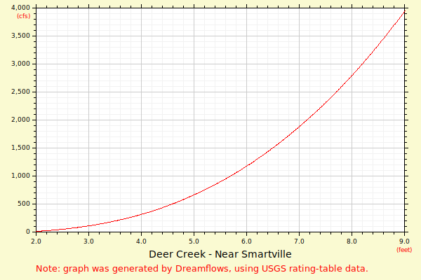

| Flow (in cfs) - last revised Aug 11, 2025 | ||||||||||
|---|---|---|---|---|---|---|---|---|---|---|
| Height (feet) | .0 | .1 | .2 | .3 | .4 | .5 | .6 | .7 | .8 | .9 |
| 1 | 1 | 1 | 3 | 4 | 5 | 8 | 10 | 13 | 17 | 22 |
| 2 | 27 | 34 | 41 | 49 | 58 | 68 | 78 | 90 | 103 | 117 |
| 3 | 132 | 148 | 165 | 183 | 203 | 224 | 246 | 269 | 294 | 320 |
| 4 | 348 | 377 | 407 | 439 | 472 | 507 | 544 | 581 | 621 | 662 |
| 5 | 705 | 749 | 795 | 843 | 893 | 944 | 997 | 1052 | 1109 | 1167 |
| 6 | 1228 | 1289 | 1352 | 1417 | 1484 | 1553 | 1624 | 1696 | 1771 | 1848 |
| 7 | 1926 | 2007 | 2090 | 2174 | 2261 | 2350 | 2441 | 2535 | 2630 | 2728 |
| 8 | 2828 | 2930 | 3034 | 3140 | 3249 | 3360 | 3474 | 3589 | 3707 | 3828 |
| 9 | 3951 | 4076 | 4203 | 4334 | 4466 | 4601 | 4738 | 4878 | 5021 | 5166 |
| 10 | 5314 | 5464 | 5616 | 5772 | 5930 | 6090 | 6253 | 6419 | 6588 | 6759 |
| 11 | 6933 | 7110 | 7289 | 7472 | 7657 | 7845 | 8035 | 8229 | 8425 | 8624 |
| 12 | 8826 | 9031 | 9239 | 9450 | 9664 | 9880 | 10100 | 10322 | 10548 | 10777 |
| Height (feet) | .0 | .1 | .2 | .3 | .4 | .5 | .6 | .7 | .8 | .9 |
| 13 | 11008 | 11243 | 11481 | 11722 | 11966 | 12213 | 12463 | 12716 | 12972 | 13232 |
| 14 | 13495 | 13761 | 14030 | 14302 | 14578 | 14857 | 15139 | 15424 | 15713 | 16005 |
| 15 | 16300 | |||||||||