| Flow (in cfs) - last revised Feb 24, 2026 | ||||||||||
|---|---|---|---|---|---|---|---|---|---|---|
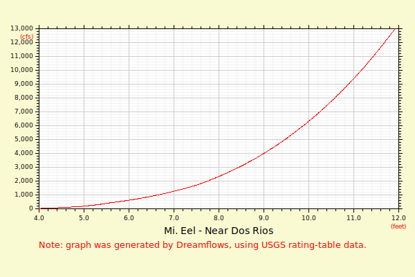
| Height (feet) | .0 | .1 | .2 | .3 | .4 | .5 | .6 | .7 | .8 | .9 |
| 2 | 1 | 3 | 6 | 10 | 15 | |||||
| 3 | 21 | 27 | 35 | 44 | 54 | 64 | 76 | 88 | 101 | 115 |
| 4 | 131 | 147 | 163 | 181 | 200 | 220 | 242 | 265 | 290 | 316 |
| 5 | 343 | 371 | 400 | 430 | 462 | 495 | 530 | 566 | 604 | 643 |
| 6 | 683 | 734 | 793 | 855 | 920 | 988 | 1060 | 1135 | 1214 | 1297 |
| 7 | 1383 | 1474 | 1568 | 1666 | 1769 | 1875 | 1986 | 2102 | 2222 | 2346 |
| 8 | 2476 | 2610 | 2749 | 2893 | 3042 | 3196 | 3356 | 3521 | 3691 | 3867 |
| 9 | 4049 | 4259 | 4476 | 4700 | 4932 | 5172 | 5420 | 5676 | 5940 | 6212 |
| 10 | 6493 | 6783 | 7081 | 7387 | 7703 | 8028 | 8363 | 8706 | 9060 | 9423 |
| 11 | 9795 | 10178 | 10571 | 10974 | 11388 | 11812 | 12247 | 12693 | 13149 | 13617 |
| 12 | 14096 | 14587 | 15089 | 15603 | 16129 | 16666 | 17216 | 17778 | 18353 | 18940 |
| 13 | 19540 | 20153 | 20779 | 21418 | 22071 | 22737 | 23416 | 24110 | 24817 | 25538 |
| Height (feet) | .0 | .1 | .2 | .3 | .4 | .5 | .6 | .7 | .8 | .9 |
| 14 | 26274 | 27024 | 27789 | 28568 | 29362 | 30171 | 30996 | 31835 | 32690 | 33561 |
| 15 | 34448 | 35350 | 36268 | 37203 | 38154 | 39121 | 40106 | 41107 | 42125 | 43160 |
| 16 | 44213 | 45282 | 46370 | 47475 | 48599 | 49740 | 50900 | 52077 | 53274 | 54489 |
| 17 | 55723 | 56976 | 58249 | 59540 | 60851 | 62182 | 63533 | 64903 | 66294 | 67705 |
| 18 | 69136 | 70588 | 72061 | 73555 | 75069 | 76605 | ||||