Truckee - Near Truckee
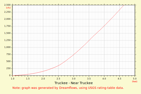
This rating table shows the relationship between gauge height and river flow for the USGS gauge, id '10338000', located on the Truckee River, 2.5 miles above the Hwy-267 bridge in Truckee, CA.
Dreamflows generated the graph and table using USGS rating table data.
NOTE: The rating table below was published Jan 14, 2026 and was valid only at that time.
The relationship between gauge height and river flow may change over time and therefore the older the rating table, the less reliable it is likely to be.
The graph shows the range of data of primary interest to boaters, while the numerical listing gives the full range of available data.
| | Flow (in cfs) - last revised Jan 14, 2026 |
|---|
| Height (feet) | .0 | .1 | .2 | .3 | .4 | .5 | .6 | .7 | .8 | .9 |
|---|
| 0 | | | | | | | | 2 | 4 | 7 |
| 1 | 12 | 18 | 26 | 36 | 48 | 62 | 79 | 98 | 121 | 148 |
| 2 | 178 | 212 | 250 | 293 | 340 | 400 | 465 | 533 | 605 | 681 |
| 3 | 760 | 842 | 928 | 1017 | 1108 | 1203 | 1301 | 1402 | 1506 | 1612 |
| 4 | 1722 | 1834 | 1949 | 2066 | 2186 | 2309 | 2434 | 2562 | 2693 | 2826 |
| 5 | 2961 | 3093 | 3227 | 3363 | 3501 | 3642 | 3784 | 3929 | 4076 | 4224 |
| 6 | 4375 | 4528 | 4683 | 4840 | 4999 | 5160 | 5323 | 5488 | 5655 | 5823 |
| 7 | 5994 | 6166 | 6341 | 6517 | 6695 | 6875 | 7057 | 7241 | 7427 | 7614 |
| 8 | 7803 | 7994 | 8187 | 8381 | 8578 | 8776 | 8975 | 9177 | 9380 | 9585 |
| 9 | 9792 | 10000 | | | | | | | | |