| Flow (in cfs) - last revised Feb 12, 2026 | ||||||||||
|---|---|---|---|---|---|---|---|---|---|---|
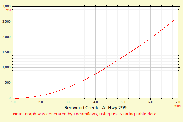
| Height (feet) | .0 | .1 | .2 | .3 | .4 | .5 | .6 | .7 | .8 | .9 |
| 0 | 2 | 4 | ||||||||
| 1 | 8 | 13 | 20 | 28 | 37 | 48 | 60 | 74 | 90 | 107 |
| 2 | 125 | 144 | 165 | 187 | 210 | 235 | 261 | 289 | 318 | 349 |
| 3 | 381 | 416 | 456 | 496 | 539 | 584 | 630 | 677 | 725 | 775 |
| 4 | 825 | 876 | 928 | 982 | 1036 | 1091 | 1147 | 1204 | 1262 | 1320 |
| 5 | 1380 | 1440 | 1501 | 1563 | 1626 | 1690 | 1754 | 1819 | 1885 | 1952 |
| 6 | 2019 | 2087 | 2156 | 2226 | 2296 | 2367 | 2438 | 2511 | 2584 | 2658 |
| 7 | 2732 | 2807 | 2883 | 2959 | 3036 | 3114 | 3192 | 3271 | 3350 | 3430 |
| 8 | 3511 | 3592 | 3674 | 3757 | 3840 | 3923 | 4008 | 4092 | 4178 | 4264 |
| 9 | 4350 | 4437 | 4525 | 4613 | 4702 | 4791 | 4881 | 4972 | 5062 | 5154 |
| 10 | 5246 | 5338 | 5431 | 5525 | 5619 | 5713 | 5808 | 5904 | 6000 | |