| Flow (in cfs) - last revised Jun 17, 2026 | ||||||||||
|---|---|---|---|---|---|---|---|---|---|---|
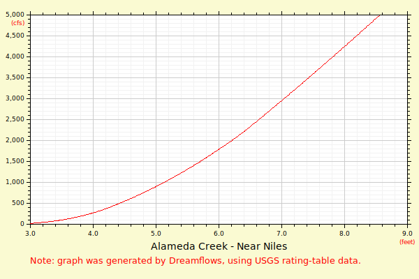
| Height (feet) | .0 | .1 | .2 | .3 | .4 | .5 | .6 | .7 | .8 | .9 |
| 2 | 0 | 0 | 1 | 2 | 3 | 5 | 9 | 13 | 18 | 25 |
| 3 | 34 | 46 | 60 | 77 | 98 | 124 | 154 | 188 | 226 | 270 |
| 4 | 317 | 367 | 419 | 475 | 535 | 598 | 664 | 734 | 807 | 883 |
| 5 | 963 | 1047 | 1133 | 1223 | 1317 | 1413 | 1510 | 1608 | 1707 | 1808 |
| 6 | 1910 | 2014 | 2119 | 2225 | 2333 | 2442 | 2552 | 2663 | 2776 | 2890 |
| 7 | 3005 | 3121 | 3239 | 3357 | 3477 | 3597 | 3719 | 3842 | 3965 | 4090 |
| 8 | 4216 | 4342 | 4470 | 4599 | 4728 | 4859 | 4990 | 5122 | 5255 | 5389 |
| 9 | 5524 | 5660 | 5796 | 5934 | 6072 | 6211 | 6351 | 6491 | 6633 | 6775 |
| 10 | 6918 | 7062 | 7206 | 7351 | 7496 | 7641 | 7787 | 7934 | 8081 | 8231 |
| 11 | 8383 | 8536 | 8689 | 8844 | 8998 | 9154 | 9320 | 9487 | 9656 | 9826 |
| 12 | 9996 | 10167 | 10340 | 10522 | 10711 | 10901 | 11093 | 11285 | 11479 | 11675 |
| 13 | 11871 | 12068 | 12267 | 12467 | 12668 | 12871 | 13074 | 13280 | 13503 | 13728 |
| Height (feet) | .0 | .1 | .2 | .3 | .4 | .5 | .6 | .7 | .8 | .9 |
| 14 | 13954 | 14181 | 14410 | 14640 | 14873 | 15106 | 15341 | 15578 | 15816 | 16055 |
| 15 | 16296 | 16539 | 16783 | 17028 | 17288 | 17551 | 17815 | 18082 | 18350 | 18620 |
| 16 | 18891 | 19165 | 19440 | 19717 | 19995 | 20276 | 20558 | 20842 | 21127 | 21415 |
| 17 | 21704 | 21994 | 22286 | 22580 | 22874 | 23171 | 23470 | 23770 | 24071 | 24375 |
| 18 | 24680 | |||||||||