| Flow (in cfs) - last revised Dec 20, 2024 | ||||||||||
|---|---|---|---|---|---|---|---|---|---|---|
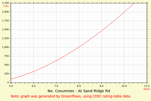
| Height (feet) | .0 | .1 | .2 | .3 | .4 | .5 | .6 | .7 | .8 | .9 |
| 3 | 0 | 2 | 6 | |||||||
| 4 | 12 | 20 | 28 | 38 | 49 | 61 | 74 | 88 | 103 | 118 |
| 5 | 135 | 153 | 171 | 190 | 210 | 231 | 253 | 275 | 298 | 322 |
| 6 | 346 | 372 | 397 | 424 | 451 | 479 | 508 | 537 | 567 | 598 |
| 7 | 629 | 661 | 693 | 726 | 760 | 794 | 829 | 865 | 901 | 937 |
| 8 | 975 | 1012 | 1051 | 1090 | 1129 | 1169 | 1210 | 1251 | 1293 | 1335 |
| 9 | 1378 | 1421 | 1465 | 1509 | 1554 | 1600 | 1646 | 1692 | 1739 | 1786 |
| 10 | 1834 | 1883 | 1932 | 1985 | 2057 | 2130 | 2204 | 2280 | 2357 | 2436 |
| 11 | 2516 | 2598 | 2681 | 2766 | 2853 | 2941 | 3030 | 3121 | 3214 | 3308 |
| 12 | 3404 | 3501 | 3600 | 3700 | 3802 | 3906 | 4011 | 4118 | 4226 | 4336 |
| 13 | 4448 | 4561 | 4676 | 4793 | 4911 | 5031 | 5153 | 5276 | 5401 | 5528 |
| 14 | 5656 | 5787 | 5918 | 6052 | 6187 | 6324 | 6463 | 6603 | 6745 | 6889 |
| Height (feet) | .0 | .1 | .2 | .3 | .4 | .5 | .6 | .7 | .8 | .9 |
| 15 | 7035 | 7182 | 7331 | 7482 | 7635 | 7789 | 7946 | 8104 | 8263 | 8425 |
| 16 | 8589 | 8754 | 8921 | 9090 | 9260 | 9433 | 9607 | 9784 | 9962 | 10142 |
| 17 | 10323 | 10507 | 10692 | 10880 | 11069 | 11260 | 11453 | 11648 | 11845 | 12044 |
| 18 | 12244 | 12447 | 12651 | 12857 | 13066 | 13276 | 13488 | 13702 | 13918 | 14136 |
| 19 | 14356 | 14578 | 14802 | 15027 | 15255 | 15485 | 15717 | 15950 | ||