| Flow (in cfs) - last revised Jun 4, 2026 | ||||||||||
|---|---|---|---|---|---|---|---|---|---|---|
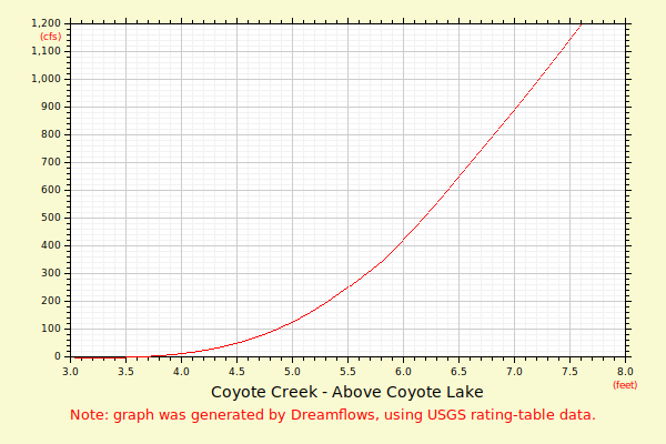
| Height (feet) | .0 | .1 | .2 | .3 | .4 | .5 | .6 | .7 | .8 | .9 |
| 4 | 0 | 1 | 2 | 5 | 9 | 15 | 24 | 34 | 47 | |
| 5 | 60 | 75 | 92 | 111 | 131 | 154 | 179 | 204 | 230 | 258 |
| 6 | 288 | 320 | 353 | 388 | 426 | 465 | 506 | 549 | 594 | 642 |
| 7 | 689 | 738 | 788 | 840 | 893 | 949 | 1006 | 1066 | 1127 | 1190 |
| 8 | 1254 | 1321 | 1390 | 1460 | 1530 | 1602 | 1674 | 1747 | 1820 | 1894 |
| 9 | 1969 | 2045 | 2121 | 2198 | 2276 | 2354 | 2433 | 2513 | 2593 | 2674 |
| 10 | 2755 | 2837 | 2920 | 3003 | 3087 | 3171 | 3256 | 3341 | 3427 | 3513 |
| 11 | 3602 | 3691 | 3780 | 3870 | 3961 | 4052 | 4144 | 4236 | 4329 | 4422 |
| 12 | 4516 | 4610 | 4705 | 4800 | 4896 | 4992 | 5089 | 5186 | 5284 | 5386 |
| 13 | 5488 | 5590 | 5693 | 5797 | 5901 | 6005 | 6110 | 6216 | 6322 | 6428 |
| 14 | 6535 | 6643 | 6751 | 6859 | 6968 | 7078 | 7188 | 7298 | 7409 | 7520 |
| 15 | 7632 | 7744 | 7857 | 7970 | 8084 | 8198 | 8312 | 8427 | 8545 | 8664 |
| Height (feet) | .0 | .1 | .2 | .3 | .4 | .5 | .6 | .7 | .8 | .9 |
| 16 | 8783 | 8903 | 9024 | 9145 | 9266 | 9388 | 9510 | 9633 | 9756 | 9880 |
| 17 | 10004 | 10129 | 10254 | 10380 | 10506 | 10632 | 10759 | 10886 | 11014 | 11142 |
| 18 | 11271 | 11400 | 11530 | 11660 | 11790 | 11921 | ||||