| Flow (in cfs) - last revised Feb 20, 2026 | ||||||||||
|---|---|---|---|---|---|---|---|---|---|---|
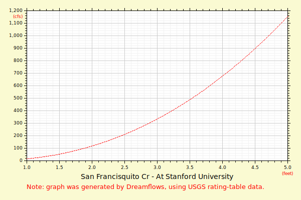
| Height (feet) | .0 | .1 | .2 | .3 | .4 | .5 | .6 | .7 | .8 | .9 |
| 0 | 0 | 0 | 1 | 2 | 4 | 6 | 9 | 13 | 17 | |
| 1 | 22 | 28 | 34 | 41 | 49 | 58 | 68 | 80 | 94 | 108 |
| 2 | 124 | 142 | 160 | 179 | 200 | 221 | 244 | 268 | 293 | 319 |
| 3 | 346 | 374 | 404 | 435 | 467 | 500 | 534 | 570 | 606 | 644 |
| 4 | 683 | 723 | 764 | 807 | 850 | 895 | 940 | 987 | 1036 | 1085 |
| 5 | 1135 | 1185 | 1235 | 1285 | 1336 | 1386 | 1437 | 1488 | 1539 | 1590 |
| 6 | 1641 | 1692 | 1744 | 1795 | 1847 | 1899 | 1951 | 2003 | 2055 | 2107 |
| 7 | 2159 | 2211 | 2264 | 2316 | 2369 | 2422 | 2474 | 2527 | 2580 | 2633 |
| 8 | 2686 | 2739 | 2793 | 2846 | 2899 | 2953 | 3006 | 3060 | 3114 | 3167 |
| 9 | 3221 | 3275 | 3329 | 3383 | 3437 | 3491 | 3545 | 3600 | 3654 | 3708 |
| 10 | 3763 | 3817 | 3872 | 3926 | 3981 | 4035 | 4090 | 4145 | 4200 | 4255 |
| 11 | 4310 | 4365 | 4420 | 4475 | 4530 | 4585 | 4640 | 4696 | 4751 | 4806 |
| Height (feet) | .0 | .1 | .2 | .3 | .4 | .5 | .6 | .7 | .8 | .9 |
| 12 | 4862 | 4917 | 4973 | 5028 | 5084 | 5140 | 5195 | 5251 | 5307 | 5363 |
| 13 | 5419 | 5475 | 5531 | 5587 | 5643 | 5699 | 5755 | 5811 | 5867 | 5923 |
| 14 | 5980 | 6036 | 6092 | 6149 | 6205 | 6262 | 6318 | 6375 | 6431 | 6488 |
| 15 | 6544 | 6601 | 6658 | 6714 | 6771 | 6828 | 6885 | 6942 | 6999 | 7056 |
| 16 | 7113 | 7170 | 7227 | 7284 | 7341 | 7398 | 7455 | 7512 | 7570 | 7627 |
| 17 | 7684 | 7742 | 7799 | 7856 | 7914 | 7971 | ||||