| Flow (in cfs) - last revised May 7, 2026 | ||||||||||
|---|---|---|---|---|---|---|---|---|---|---|
| Height (feet) | .0 | .1 | .2 | .3 | .4 | .5 | .6 | .7 | .8 | .9 |
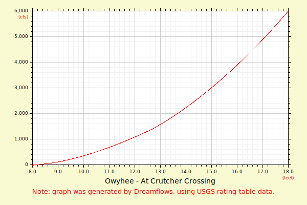
| 7 | 3 | |||||||||
| 8 | 9 | 16 | 25 | 34 | 45 | 58 | 71 | 85 | 100 | 116 |
| 9 | 132 | 151 | 172 | 194 | 217 | 241 | 266 | 292 | 319 | 347 |
| 10 | 375 | 404 | 435 | 465 | 497 | 530 | 563 | 597 | 632 | 667 |
| 11 | 704 | 741 | 778 | 817 | 856 | 896 | 936 | 977 | 1019 | 1061 |
| 12 | 1105 | 1148 | 1193 | 1238 | 1283 | 1329 | 1376 | 1425 | 1482 | 1541 |
| 13 | 1601 | 1662 | 1725 | 1788 | 1853 | 1918 | 1985 | 2053 | 2122 | 2192 |
| 14 | 2263 | 2335 | 2409 | 2483 | 2559 | 2636 | 2714 | 2793 | 2873 | 2955 |
| 15 | 3037 | 3121 | 3205 | 3291 | 3378 | 3466 | 3555 | 3645 | 3737 | 3829 |
| 16 | 3923 | 4017 | 4112 | 4209 | 4307 | 4405 | 4505 | 4606 | 4708 | 4812 |
| 17 | 4916 | 5021 | 5128 | 5235 | 5344 | 5454 | 5565 | 5677 | 5790 | 5904 |
| 18 | 6019 | 6136 | 6253 | 6372 | 6491 | 6612 | 6734 | 6857 | 6981 | 7106 |
| Height (feet) | .0 | .1 | .2 | .3 | .4 | .5 | .6 | .7 | .8 | .9 |
| 19 | 7232 | 7360 | 7489 | 7619 | 7750 | 7882 | 8016 | 8150 | 8285 | 8422 |
| 20 | 8560 | 8698 | 8838 | 8979 | 9121 | 9265 | 9409 | 9554 | 9701 | 9848 |
| 21 | 9997 | 10147 | 10297 | 10449 | 10602 | 10757 | ||||